


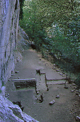
The rockshelter Boila is situated in Epirus on the western end of the valley of the Voidomatis river (Vikos gorge) at a height of approximately 500 metres. Today the rockshelter measures 17X5 metres, is oblong in shape but not very deep. Geological studies however, have found evidence that it was more sheltered in the past and its natural roof collapsed gradually under the effect of natural phenomena (erosion, earthquakes).
The geographical position of the rockshelter, between the mountain chain Timfi in the east, and the almost level basin of Konitsa in the west, constitutes a particularly important factor in the study and interpretation of how the hunter-gatherers of northwest Epirus adapted to two different ecosystems.
Systematic excavations of a 1/3 of the rockshelter's floor, has dated its use to the last Glaciation. This geological period corresponds with the Final Upper Palaeolithic (Epigravettian cultural phase). The layers, about 80 cm thick, were rich in hearths, lithic, bone and antler artefacts, fauna remains and animal bones. These finds have contributed to a reconstruction of the economic behaviour of the hunter-gatherers at Voidomatis valley for the period 14,000-10,000 BP.
Together with Boila, the rockshelters Kleidi and Megalakkos were used seasonally from the 14th millennium BP. The site Kleidi seems to be the most important among the three rockshelters at Vikos gorge for the period 16,000-13,000 BP. Only during the transition from the Pleistocene to the Holocene did Boila appear to play an important economic role at Voidomatis valley.
The research at the Boila rockshelter forms part of the Palaeolithic excavations which are being conducted at the Voidomatis and Aoos valleys and which were begun in 1993 by the scientific research team of the Ephorate of Palaeanthropology-Speleology of the Hellenic Ministry of Culture.