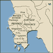
The tablets of the palace archives provide evidence on the Bronze Age placenames. The placenames were used in the Mycenaean texts to show the origin of the people and goods which were traded in the palatial centres. The tablets of Knossos include about one-hundred names of settlements and the tablets of Pylos about one-hundred and sixty. The specialists try to identify the Mycenaean placenames with specific sites. This research is likely to lead to wrong conclusions since many sites could have the same placename in the Mycenaean years as in Antiquity. The texts of the tablets of Pylos reveal that Messenia was divided in seven administrative units, Pissa, Rio, Kyparisso, Loussous, Sphagianes and Nedona. The inhabitants of these regions were subjected to the king of Pylos. Crete had a powerful Mycenaean centre, Knossos, which controlled the whole island until the collapse of the palace when the power was shared to many smaller regions. The names of some Cretan towns, such as Kydonia, Lato, Inatos and Syvrita are identified on the tablets of Knossos. These placenames appear identical or slightly modified in ancient Greek. The way the placenames appear in the Mycenaean texts presents great philological interest. The same suffixes which were used for the placenames of the ancient Greek language are employed to define specific Mycenaean sites. Greek suffixes are even added to non Greek placenames which usually end in -so (-issos) and -to (-inthos), e.g. aminiso (Amnissos), konoso (Knossos), korito (Corinthos), ruso (Loussos), turiso (Tylissos). The placenames have various endings. Typical endings are: -i-jo (ios and -ia) and -uwa (-υFa) e.g. rijo (Rion) and kudonia (Kydonia), in -o, e.g. puro (Pylos), -ipo, e.g. Ewiripo (Euripos). The locations are often determined by names of persons in the genitive case followed by the word wowo which determined the frontiers of a region. |
 |
|
|
Pylos. Map with the administrative units.
|
||